February 28, 2010

Monsoon low edges closer to the South East Qld

A monsoon low that has been causing heavy rain and localised flooding over the Northern Territory is making it's way into Queensland and heading for the south-east corner.

The Bureau of Meteorology issued a Severe Weather Warning yesterday for the Channel Country (south-western Qld including Birdsville) for flash flooding.

Updated: Tsunami threat eases, Gold Coast beaches remain closed

UPDATE: The BOM has issued a cancellation of the tsunami warning for Queensland at 4:11pm. The main tsunami waves have passed, but small unusual waves, currents & abnormal tides may exist for hours or even days. Emergency Management Queensland will advise when it's safe to return to coastal areas.

ORIGINAL: POST: The latest Tsunami bulletin from the JATWC & BOM at 3:11pm still warns of potential dangerous waves and strong ocean currents, however foreshore inundation is no longer expected with the 'assistance' of an outgoing tide.

Gold Coast beaches are to remain closed for the remainder of today (Sunday 28th February).

February 27, 2010

Chile Earthquake prompts tsunami bulletin for QLD

An 8.8 magnitude earthquake off the coast of Chile, South America has prompted the Joint Australian Tsunami Warning Centre to issue a Tsunami Bulletin for Queensland and New South Wales as well as Norfolk and Lord Howe Islands

Rain on the way for the South East

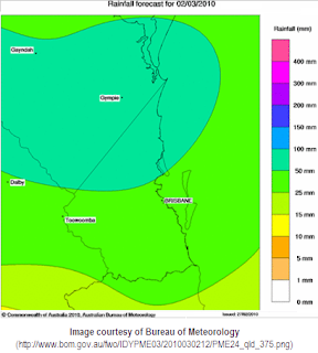
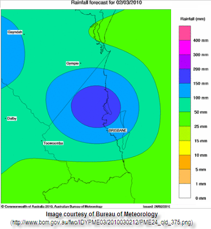
According to Bureau of Meteorology computer generated forecast rainfall maps, it looks like it's going to get wetter in the South-East corner from now until Tuesday.

The rainfall forecast maps show an expected 10-15mm falling in the Gold Coast area on Sunday, 15-25mm on Monday, and between 25-50mm in the south and 50-100mm in the northern areas of the Gold Coast.

February 16, 2010

More storms, cars swim in Brisbane!

The Severe Thunderstorm Warning was issued early today before midday for heavy falls and flash flooding, coming in diagonally from the north-west with some moderate-heavy falls.

February 15, 2010

Gold Coast Thunderstorms 15th Feb 2010

Thunderstorms rolled into the Gold Coast area today at around 8-9pm, however most of the intensity was spent over the Fassifern Valley area and the Brisbane bayside.


February 14, 2010

Welcome to weathergc.com!

Thanks for visiting weathergc.com, your window to Gold Coast weather!

Our main aim since February 2010 is to provide a place for the residents and visitors to the Gold Coast to share their experiences and knowledge about how the weather is affecting their neck of the woods. We'll also share information and the best links from other official sources including weather forecasts and warnings, observations, satellite & radar imagery , power outages and road/transport closures, etc.

Often when severe weather events occur on the Gold Coast, it can be hours or days before the full extent of what's happened, in what area, to which people. We hope that through our blog (at http://www.weathergc.com), our Twitter updates (via @weathergc) and via our Facebook page (http://facebook.com/weathergc), that everyone can share their personal experiences, local observations as well as photos and videos.

So if it's raining cats and dogs at your place, the couch is floating out the door, or you can't find the candles (but you have your mobile with a Twitter or Facebook account!), we want to know about it! Post a picture, leave a comment, or a Tweet!

Please note that any information posted/tweeted are opinions based on personal experiences and information passed on from other sources for entertainment purposes only. This information may not be accurate, and should not be relied upon as the single point of truth. It is recommended that you refer directly to the official sources of information, forecasts and warnings, etc (i.e. from the Bureau of Meteorology, SES, Energex, etc) to make an informed decision.

Thanks for reading, we look forward to your input and participation!